

`Art that reworks the landscape`, Wapke Feenstra (ENG)
Ruimte, vakblad Vlaamse vereniging voor ruimte en planning, Vlaams Bouwmeester, juni - juli - aug 2012
The landscape in traditional painting may be a green and pleasant domain, an Arcadian idyll, or a dark realm fraught with menace. Because dreams, fears and other indefinable sentiments are an integral part of landscape. Initially, I was surprised by the enduring popularity of the two-dimensional representation of our surroundings. I was born and bred in a landscape, but years passed before it even dawned on me that there was an art genre that related to land differently from the way we did on the farm. It started to crystallize out when the first tourists turned up, when faraway worlds were aired on television, and when some Amsterdam hippies bought homes in our village.
The world was getting bigger and people seemed to find some kind of meaning in grazing cows and acres of sugar beet that had escaped me completely. Not that my childhood was devoid of aesthetic experiences, they were just of a different kind. Looking into the brown eyes of a cow, deep and intuitive, brushed with lustrous black lashes. Stretching out on the grass, gazing at the stars until we were dizzy. Or watching the differently shaped clouds scud across the sky every day; always there, but always elusive.
Yes, my landscape is often nostalgic, sometimes aloof, and occasionally enlarged, as if under a magnifying glass. At the start of this century, I want to widen our perspective on landscape, to zoom out from a close-up to a master shot, so that what we see can never become frozen. We need to reconceive our landscape again and again.
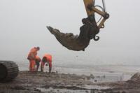
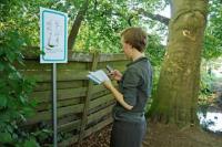
And in Spring 2007 we started at the most basic level, with an auger. We made drillings with an auger, transferred the soil into sealable bags and noted the depth at which we found it.
The experience of standing on the land as you look around and point out everything you see changes as soon as the auger enters the earth. The conversation is less encompassing; land becomes something with qualities and physical properties. The owner explains the water cycle, the farmer talks about the harvest and the maintenance. The soil expert rubs the grains with his fingers, grinds it between his teeth and tells us the composition. As an artist, I see all of this as an event, because lots of photographs are being taken, questions are being asked and people are explaining and writing things down. For a short time, our experiences gel: we see the landscape. We turn it into our cultural place and mark it literally with the drilling.
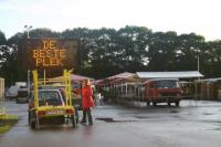
The Best Place
Why do people grow so attached to certain places or views. In the east of the Netherlands on the River Vecht in Overijssel is the town of Hardenberg. It is situated in a rural area with land consisting of excavated peat so its busy farming country. There are long, straight canals and a few sandbanks with a lake and a stream that campers love. Hardenberg is not a major national tourist attraction and the residential space is shrinking. But I could see clearly, even during my first visit, that people liked to live here. Some had been there for generations, others had moved there because they had found work.
In the summer of 2007 I made a special appeal to the local residents when I distributed flyers door-to-door, inviting them to share their own idea of The Best Place. Send Wapke to `The Best Place` and tell her why she should visit it. If youd like to contribute to this art book and if you know a place that Wapke shouldnt miss, then get in touch right away.
Knowing that there is no such thing as The Best Place, the attention the invitation received from the local press and the municipality was encouraging. It helped to get things moving. The Best Place is a place where you do things, where the desire for a physical location and an activity converge for a while. Any publicly accessible place could be nominated and the book would take the form of a journey. More than eighty nominations arrived; I spent a month visiting the first batch of entries that arrived. I visited The Best Place on fourteen occasions, and the next day I edited and digitally stored all the notes I had made so that they could be included in the book. Sundays were set aside for R & R.
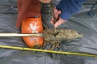
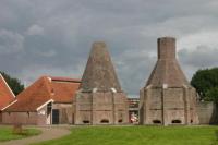
It was summer. I mounted a solar-powered digital traffic sign on a trailer which I hooked up to my car. It said The Best Place. The nominators of the fourteen locations had been told to expect me and helped me to create an optimal day at The Best Place. When I visited monuments and events which had been nominated several times over, it was a bigger group that left an imprint on my day. Usually there were four or five of us. I arrived at the marketplace in Hardenberg and parked my trailer, then I wandered around a local estate, surveyed a field of sugar beet, made a herbarium, admired some beautifully restored lime kilns in Dedemsvaart and went on a fishing expedition with a father and son. The biggest fish that we caught was a tench. Every day at The Best Place ended with a soil sample. I drilled a metre deep, emptied the soil into sealable bags and took it back to the studio. Later, the photographed soil marked the chapter about that day. The chapter also contained a photo shoot about the place and a topical story.
The journey to The Best Place was an art project, not just in the form of a book, but as an event as well. It was all explicitly performative: it happened, it made experiences cultural and immediate, and it created a new image of the surroundings right there and then. We made a new landscape an event which is as complex as it is simple. At micro level the project was about a rural area. It consisted of an open question, a journey and a travel book. At macro level The Best Place contextualized the debate about the ritualization of culture and the often forgotten relationship with the land. It was about the wondrous world of striking roots, settling down and building a life.
Under Sand
My name is Wapke Feenstra. Feenstra means: born on peaty soil. Actually the soil I was born on was clayey, but my ancestors did indeed come from peatland. Wapke means either water spring or forest, there are different schools of thought about that. I have a Frisian name, you can tell that from the ending: all Frisian names end in either stra or sma. My ability to speak fluent Frisian completes the picture. Many people associate the Frisian landscape with distinguished horses or herds of black and white cows grazing in ditch-enclosed fields. My name belongs in the region where I grew up, not where I live now, in what is called an urban priority neighbourhood in Rotterdam. At the moment priority is being accorded there to the many Poles and Bulgarians who have recently moved in.
I am Wapke Feenstra, but if my surname had come from my mother and grandmother it would be Eastern European. And that conjures up other images. It isnt just people, but also languages and names that people associate with a landscape. Places can also trigger visions of landscape. Some landscapes cry out for communication here and now. In 2008 I found myself standing on the bank of the Ebro in Zaragoza in Spain, watching a new office district and park being built in the run-up to EXPO 08. Looking at the sand-filled trucks driving to and fro, I wondered what had stood here before. Nothing, was the answer. Nothing?
Nothing made me curious, especially when it was being buried under sand. Later I learned that the land had been used for growing vegetables. Two farming families still lived nearby. I wanted to meet them, but it wasnt easy as the high price they had received for their land had been given wide coverage in the press. I managed to convince them that the stories they had to tellwere both fascinating and of cultural value. Suddenly I was in contact with six farmers who owned land here.
And that marked the start of Former Farmland, a series of walks past landmarks, like old trees that have been left behind or a characteristic waters edge where an office block stands, or a re-used barn. I walked across land that had been worked by generations of farmers and heard that, even in Roman times, vegetables had been cultivated here for the people of Zaragoza.
It had all come to an end two years previously. I recorded the memories of the last farmers about the use of the land and illustrated them with photos of what the farmers and their families now grew and processed. I put it all on a website so that it could be publicly accessed.
A sign had been placed beside each landmark and we took turns at reading them during the tour. In 2008 Nokia and Vodafone were marketing mobile phones that had internet and a new image-recognition system a radical innovation at the time, but now supplanted by apps.
Word got around of the Former Farmland project and I made three versions within a year; in Zaragoza during EXPO 08, in Linz (Austria) during the Ars Electronica Festival, and for Landschaft 2.0 in Oldenburg (Lower Saxony, Germany). Twenty-five farmers, farm workers and their sons and daughters talked about Former Farmland, and brought the layers that underlie the office blocks and residential estates back to life.
Moving Landscape
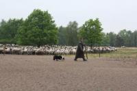
In the Belgian province of Limburg the coal mines have been closed for so long that the slack is richly overgrown with grass, trees and plants. Further into the province you find apple orchards and potato fields. A flock of sheep grazes on the heath, and gravel and quartz sand are wet-mined. This is the primary industry here: it interacts directly with the natural resources, utilizing the earths crust and allowing it to produce a (crude) product. Such direct intervention means that the landscape is constantly changing in appearance.
In 2009 I visited six places in Limburg and asked the land utilizers to participate in the Moving Landscape project. We started by having a meal together to get acquainted. In 2010 I kept track of potato planting, sand vacuuming, gravel mining and apple picking. It was a wonderful year: I was outdoors in all seasons, learning from experts and taking lots of photos. I joined the sand, gravel and potato transports, my journey ending only when the product changed owners. The boat, lorry, train and jeep then went on to their next job.
I recorded all sorts of information and made notes for my photo series. My Moving Landscape report was then distributed through the newsletters of FLACC (workplace for the visual arts). But all these movements above-ground paled into insignificance when geologist Michiel Dusar joined me on another visit to the six places and enthralled us all with stories about violent ruptures in the earths crust, weathering, floods and subsidence. It was almost impossible to imagine that it took millions billions of years of movement to make this part of Belgium habitable and workable. I sketched the geological evolution and converted it into six animations from the earliest unfolding of the landscape to cultivation. The animation was followed by a slide show that showed in detail the current process of cultivation, production and transportation (2010). The result was shared with the public via a programme on a touch screen shown by Z33 at the PIT exhibition in Borgloon in 2011 and later in the hall of C-mine in Genk. It can, of course, also be viewed online at www.bewegendlandschap.be and the touch screen is still at the FLACC workplace in Genk in 2012.
Object of desire
Needless to say, economics, production and ownership play a leading role at all six locations in the Limburg landscape. These are also the reasons why these people were constantly reworking the top layer of the earths crust. However, Art makes another claim on the landscape that goes beyond representation, by asking that attention be paid to the elusive aspects, the fears and dreams. At the end of the day, these art projects are not about research, entertainment, or reporting. All these elements play a role, of course, but it is visual art within the tradition of conceptual art which asks questions of the space, which mixes the roles of producer and consumer, and which includes rather than excludes the public. It is art that incorporates, that prompts us to take action and thus allows us to create other landscapes from our surroundings.
Places change, so do art and landscape. Landscape has not been just an art genre in recent decades. The two-dimensional contextualization has become common property. We see the rural environment as an image that serves us. The transition from an agricultural and mining economy to a service and above all non-land-based economy has fixed our view of the landscape. It is now an object of desire, we build the picture that we long for. We want a panoramic view, but while we moan about maize fields and phone masts polluting the horizon, our smartphone lies on the table and we eat beef from maize-fed cattle. Fortunately alongside the dinner parties the dislodgement of a habituated aesthetic vision is a tried and tested game in art. And the landscape game is urgent. My contribution was to shadow the utilizers of landscape and record their activities in photographs and words; it brought some movement into landscape as a genre which will be continued. Nothing surer.
-
Wapke Feenstra (Hennaarderadeel, 1959) lives and works in Rotterdam. In the early 1990s she participated in the postgraduate programme in visual arts at Jan van Eyck Academy in Maastricht and was awarded a Prix de Rome at the Rijksacademie in Amsterdam in 1993. As an artist, she explores local knowledge which she then shares with her audience. Her projects are multidisciplinary. In 1996 she was co-initiator of NEsTWORK during Manifesta 1 in Rotterdam and in 1999 she compiled a digital collection of stories in Dordrecht as a public work of art. In 2003 she co-founded the artists platform myvillages.org with Antje Schiffers (Berlin) and Kathrin Böhm (London). In the past ten years Feenstra has been working on art projects that focus on rural settings and culture. Her projects show the landscape, the utilizers of the landscape, and their raw materials and products. In the Vorratskammer 2010-2011, for example, a project which she showed in association with myvillages.org in the Haus der Kulturen der Welt in Berlin, food was collected in and around Berlin for a whole year. It was then processed and later it was eaten by the eight thousand visitors to the five-day Über Lebenskunst Festival. As co-editor of myvillages.org, Feenstra contributed to the conference and the book Images of Farming (2010-2011), published by Jap Sam Books Heiningen. In the autumn of 2012 A Photographic Portrait of a Landscape, the second book in the myvillages.org series, is due for publication. This time the theme is the terp landscape and the creation of cultural centres.
www.wapke.nl
Header:
The journey to The Best Place, a project by Frisian-born artist Wapke Feenstra, is a performative event which invests experiences with a cultural and immediate dimension and creates another image of the surroundings here and now. A new landscape unfolds.
About the projects:
Soil drilling has been applied in various projects since 2007. All the samples are collected and saved.
The Best Place (2007) was funded by Kunst en Kultuur in Overijssel (Netherlands). Curators: Let Geerling and Robert-Jan Muller. Production and advice: Municipality of Hardenberg. The Best Place is obtainable from Jap Sam Books.
Former Farmland (2008 and 2009) was co-produced with Artcircolo & Vodafone and was realized during EXPO 08 in Zaragoza, the Ars Electronica Festival (2008) and in the Landschaft 2.0 exhibition at the Edith Russ Haus in Oldenburg (2009).
Moving Landscape was co-developed with FLACC in 2009 at the invitation of Ronald van de Sompel. It was produced and presented in Z33, FLACC and C-mine in 2010 and 2011.
Ruimte, vakblad Vlaamse vereniging voor ruimte en planning, Vlaams Bouwmeester, juni - juli - aug 2012
The landscape in traditional painting may be a green and pleasant domain, an Arcadian idyll, or a dark realm fraught with menace. Because dreams, fears and other indefinable sentiments are an integral part of landscape. Initially, I was surprised by the enduring popularity of the two-dimensional representation of our surroundings. I was born and bred in a landscape, but years passed before it even dawned on me that there was an art genre that related to land differently from the way we did on the farm. It started to crystallize out when the first tourists turned up, when faraway worlds were aired on television, and when some Amsterdam hippies bought homes in our village.
The world was getting bigger and people seemed to find some kind of meaning in grazing cows and acres of sugar beet that had escaped me completely. Not that my childhood was devoid of aesthetic experiences, they were just of a different kind. Looking into the brown eyes of a cow, deep and intuitive, brushed with lustrous black lashes. Stretching out on the grass, gazing at the stars until we were dizzy. Or watching the differently shaped clouds scud across the sky every day; always there, but always elusive.
Yes, my landscape is often nostalgic, sometimes aloof, and occasionally enlarged, as if under a magnifying glass. At the start of this century, I want to widen our perspective on landscape, to zoom out from a close-up to a master shot, so that what we see can never become frozen. We need to reconceive our landscape again and again.
And in Spring 2007 we started at the most basic level, with an auger. We made drillings with an auger, transferred the soil into sealable bags and noted the depth at which we found it.
The experience of standing on the land as you look around and point out everything you see changes as soon as the auger enters the earth. The conversation is less encompassing; land becomes something with qualities and physical properties. The owner explains the water cycle, the farmer talks about the harvest and the maintenance. The soil expert rubs the grains with his fingers, grinds it between his teeth and tells us the composition. As an artist, I see all of this as an event, because lots of photographs are being taken, questions are being asked and people are explaining and writing things down. For a short time, our experiences gel: we see the landscape. We turn it into our cultural place and mark it literally with the drilling.
The Best Place
Why do people grow so attached to certain places or views. In the east of the Netherlands on the River Vecht in Overijssel is the town of Hardenberg. It is situated in a rural area with land consisting of excavated peat so its busy farming country. There are long, straight canals and a few sandbanks with a lake and a stream that campers love. Hardenberg is not a major national tourist attraction and the residential space is shrinking. But I could see clearly, even during my first visit, that people liked to live here. Some had been there for generations, others had moved there because they had found work.
In the summer of 2007 I made a special appeal to the local residents when I distributed flyers door-to-door, inviting them to share their own idea of The Best Place. Send Wapke to `The Best Place` and tell her why she should visit it. If youd like to contribute to this art book and if you know a place that Wapke shouldnt miss, then get in touch right away.
Knowing that there is no such thing as The Best Place, the attention the invitation received from the local press and the municipality was encouraging. It helped to get things moving. The Best Place is a place where you do things, where the desire for a physical location and an activity converge for a while. Any publicly accessible place could be nominated and the book would take the form of a journey. More than eighty nominations arrived; I spent a month visiting the first batch of entries that arrived. I visited The Best Place on fourteen occasions, and the next day I edited and digitally stored all the notes I had made so that they could be included in the book. Sundays were set aside for R & R.
It was summer. I mounted a solar-powered digital traffic sign on a trailer which I hooked up to my car. It said The Best Place. The nominators of the fourteen locations had been told to expect me and helped me to create an optimal day at The Best Place. When I visited monuments and events which had been nominated several times over, it was a bigger group that left an imprint on my day. Usually there were four or five of us. I arrived at the marketplace in Hardenberg and parked my trailer, then I wandered around a local estate, surveyed a field of sugar beet, made a herbarium, admired some beautifully restored lime kilns in Dedemsvaart and went on a fishing expedition with a father and son. The biggest fish that we caught was a tench. Every day at The Best Place ended with a soil sample. I drilled a metre deep, emptied the soil into sealable bags and took it back to the studio. Later, the photographed soil marked the chapter about that day. The chapter also contained a photo shoot about the place and a topical story.
The journey to The Best Place was an art project, not just in the form of a book, but as an event as well. It was all explicitly performative: it happened, it made experiences cultural and immediate, and it created a new image of the surroundings right there and then. We made a new landscape an event which is as complex as it is simple. At micro level the project was about a rural area. It consisted of an open question, a journey and a travel book. At macro level The Best Place contextualized the debate about the ritualization of culture and the often forgotten relationship with the land. It was about the wondrous world of striking roots, settling down and building a life.
Under Sand
My name is Wapke Feenstra. Feenstra means: born on peaty soil. Actually the soil I was born on was clayey, but my ancestors did indeed come from peatland. Wapke means either water spring or forest, there are different schools of thought about that. I have a Frisian name, you can tell that from the ending: all Frisian names end in either stra or sma. My ability to speak fluent Frisian completes the picture. Many people associate the Frisian landscape with distinguished horses or herds of black and white cows grazing in ditch-enclosed fields. My name belongs in the region where I grew up, not where I live now, in what is called an urban priority neighbourhood in Rotterdam. At the moment priority is being accorded there to the many Poles and Bulgarians who have recently moved in.
I am Wapke Feenstra, but if my surname had come from my mother and grandmother it would be Eastern European. And that conjures up other images. It isnt just people, but also languages and names that people associate with a landscape. Places can also trigger visions of landscape. Some landscapes cry out for communication here and now. In 2008 I found myself standing on the bank of the Ebro in Zaragoza in Spain, watching a new office district and park being built in the run-up to EXPO 08. Looking at the sand-filled trucks driving to and fro, I wondered what had stood here before. Nothing, was the answer. Nothing?
Nothing made me curious, especially when it was being buried under sand. Later I learned that the land had been used for growing vegetables. Two farming families still lived nearby. I wanted to meet them, but it wasnt easy as the high price they had received for their land had been given wide coverage in the press. I managed to convince them that the stories they had to tellwere both fascinating and of cultural value. Suddenly I was in contact with six farmers who owned land here.
And that marked the start of Former Farmland, a series of walks past landmarks, like old trees that have been left behind or a characteristic waters edge where an office block stands, or a re-used barn. I walked across land that had been worked by generations of farmers and heard that, even in Roman times, vegetables had been cultivated here for the people of Zaragoza.
It had all come to an end two years previously. I recorded the memories of the last farmers about the use of the land and illustrated them with photos of what the farmers and their families now grew and processed. I put it all on a website so that it could be publicly accessed.
A sign had been placed beside each landmark and we took turns at reading them during the tour. In 2008 Nokia and Vodafone were marketing mobile phones that had internet and a new image-recognition system a radical innovation at the time, but now supplanted by apps.
Word got around of the Former Farmland project and I made three versions within a year; in Zaragoza during EXPO 08, in Linz (Austria) during the Ars Electronica Festival, and for Landschaft 2.0 in Oldenburg (Lower Saxony, Germany). Twenty-five farmers, farm workers and their sons and daughters talked about Former Farmland, and brought the layers that underlie the office blocks and residential estates back to life.
Moving Landscape
In the Belgian province of Limburg the coal mines have been closed for so long that the slack is richly overgrown with grass, trees and plants. Further into the province you find apple orchards and potato fields. A flock of sheep grazes on the heath, and gravel and quartz sand are wet-mined. This is the primary industry here: it interacts directly with the natural resources, utilizing the earths crust and allowing it to produce a (crude) product. Such direct intervention means that the landscape is constantly changing in appearance.
In 2009 I visited six places in Limburg and asked the land utilizers to participate in the Moving Landscape project. We started by having a meal together to get acquainted. In 2010 I kept track of potato planting, sand vacuuming, gravel mining and apple picking. It was a wonderful year: I was outdoors in all seasons, learning from experts and taking lots of photos. I joined the sand, gravel and potato transports, my journey ending only when the product changed owners. The boat, lorry, train and jeep then went on to their next job.
I recorded all sorts of information and made notes for my photo series. My Moving Landscape report was then distributed through the newsletters of FLACC (workplace for the visual arts). But all these movements above-ground paled into insignificance when geologist Michiel Dusar joined me on another visit to the six places and enthralled us all with stories about violent ruptures in the earths crust, weathering, floods and subsidence. It was almost impossible to imagine that it took millions billions of years of movement to make this part of Belgium habitable and workable. I sketched the geological evolution and converted it into six animations from the earliest unfolding of the landscape to cultivation. The animation was followed by a slide show that showed in detail the current process of cultivation, production and transportation (2010). The result was shared with the public via a programme on a touch screen shown by Z33 at the PIT exhibition in Borgloon in 2011 and later in the hall of C-mine in Genk. It can, of course, also be viewed online at www.bewegendlandschap.be and the touch screen is still at the FLACC workplace in Genk in 2012.
Object of desire
Needless to say, economics, production and ownership play a leading role at all six locations in the Limburg landscape. These are also the reasons why these people were constantly reworking the top layer of the earths crust. However, Art makes another claim on the landscape that goes beyond representation, by asking that attention be paid to the elusive aspects, the fears and dreams. At the end of the day, these art projects are not about research, entertainment, or reporting. All these elements play a role, of course, but it is visual art within the tradition of conceptual art which asks questions of the space, which mixes the roles of producer and consumer, and which includes rather than excludes the public. It is art that incorporates, that prompts us to take action and thus allows us to create other landscapes from our surroundings.
Places change, so do art and landscape. Landscape has not been just an art genre in recent decades. The two-dimensional contextualization has become common property. We see the rural environment as an image that serves us. The transition from an agricultural and mining economy to a service and above all non-land-based economy has fixed our view of the landscape. It is now an object of desire, we build the picture that we long for. We want a panoramic view, but while we moan about maize fields and phone masts polluting the horizon, our smartphone lies on the table and we eat beef from maize-fed cattle. Fortunately alongside the dinner parties the dislodgement of a habituated aesthetic vision is a tried and tested game in art. And the landscape game is urgent. My contribution was to shadow the utilizers of landscape and record their activities in photographs and words; it brought some movement into landscape as a genre which will be continued. Nothing surer.
-
Wapke Feenstra (Hennaarderadeel, 1959) lives and works in Rotterdam. In the early 1990s she participated in the postgraduate programme in visual arts at Jan van Eyck Academy in Maastricht and was awarded a Prix de Rome at the Rijksacademie in Amsterdam in 1993. As an artist, she explores local knowledge which she then shares with her audience. Her projects are multidisciplinary. In 1996 she was co-initiator of NEsTWORK during Manifesta 1 in Rotterdam and in 1999 she compiled a digital collection of stories in Dordrecht as a public work of art. In 2003 she co-founded the artists platform myvillages.org with Antje Schiffers (Berlin) and Kathrin Böhm (London). In the past ten years Feenstra has been working on art projects that focus on rural settings and culture. Her projects show the landscape, the utilizers of the landscape, and their raw materials and products. In the Vorratskammer 2010-2011, for example, a project which she showed in association with myvillages.org in the Haus der Kulturen der Welt in Berlin, food was collected in and around Berlin for a whole year. It was then processed and later it was eaten by the eight thousand visitors to the five-day Über Lebenskunst Festival. As co-editor of myvillages.org, Feenstra contributed to the conference and the book Images of Farming (2010-2011), published by Jap Sam Books Heiningen. In the autumn of 2012 A Photographic Portrait of a Landscape, the second book in the myvillages.org series, is due for publication. This time the theme is the terp landscape and the creation of cultural centres.
www.wapke.nl
Header:
The journey to The Best Place, a project by Frisian-born artist Wapke Feenstra, is a performative event which invests experiences with a cultural and immediate dimension and creates another image of the surroundings here and now. A new landscape unfolds.
About the projects:
Soil drilling has been applied in various projects since 2007. All the samples are collected and saved.
The Best Place (2007) was funded by Kunst en Kultuur in Overijssel (Netherlands). Curators: Let Geerling and Robert-Jan Muller. Production and advice: Municipality of Hardenberg. The Best Place is obtainable from Jap Sam Books.
Former Farmland (2008 and 2009) was co-produced with Artcircolo & Vodafone and was realized during EXPO 08 in Zaragoza, the Ars Electronica Festival (2008) and in the Landschaft 2.0 exhibition at the Edith Russ Haus in Oldenburg (2009).
Moving Landscape was co-developed with FLACC in 2009 at the invitation of Ronald van de Sompel. It was produced and presented in Z33, FLACC and C-mine in 2010 and 2011.

 Kunst die het landschap bewerkt - Ruimte 14